
Cold Winds and Current Conditions
Let’s head outside. The camera shows shaking in that north wind tonight. Temperature is 31, and we’ve got a little sleet falling at San Antonio International. It feels like 19 due to the northeast wind at 20 MPH. The dew point is 14, which is half of the air temperature, explaining why much of what radar detects is not reaching the surface.
Overnight Temperature Drop
These are the lows for Tuesday morning: 25 to 26 between Holous and San Antonio International, 25 at Lackland, 26 at Sein, and possibly as cold as 23 for Bernie and 22 for Bandera. Temperature fluctuations will be minimal due to cloud cover and light precipitation.
Dew Point and Saturation Levels
The dew point will rise to about 23 overnight and then drop again tomorrow night. As temperatures and dew points align, nearing saturation, more precipitation may reach the surface. This trend is crucial for overnight developments.
Precipitation Trends
The radar shows thinning precipitation in West Bear County, while areas like Medina County and Bandera still experience thicker moisture pockets. Freezing rain and sleet persist along Highway 87, especially near Eastern Bear County and the I-10 corridor.
Overnight Snow Possibility
Between 2 and 4 a.m., there could be a burst of moisture leading to decent snow. Temperatures will drop to 28, and dew points will rise to about 22 or 23, increasing the likelihood of surface accumulation. By 7 to 8 a.m., this moisture will push out toward the Texas coast.
Wind Chill and Tomorrow’s Weather
Tomorrow morning, wind speeds will gust between 25 and 30 MPH, dropping the wind chill to 15 in San Antonio and single digits in the hill country. However, sunshine in the afternoon will help melt any frozen areas.
Snow and Ice Accumulation
Accumulation forecasts have changed. Ice levels are now at 0 for San Antonio, and snow accumulation has dropped to about half an inch. Earlier forecasts predicted up to 1.5 inches, but precipitation amounts have decreased significantly.
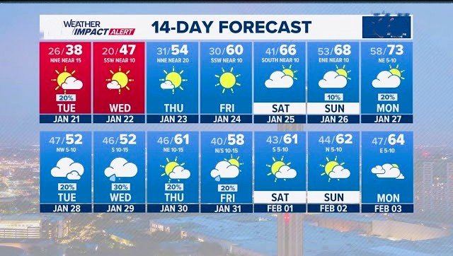
The 14-Day Weather Outlook
Two weather impact alerts are in place for tomorrow. Temperatures will only reach about 38 degrees, but sunshine will return. The coldest air arrives Wednesday morning with lows of 20 in the city and widespread teens elsewhere, causing a hard freeze. Conditions will remain dry, and temperatures will gradually recover to the upper 60s by the weekend. Rain chances will increase at the end of January, with a promising start to February.