
Georgia Power Outage: A Comprehensive Update Amid Winter Storm Warnings
The state of Georgia is currently grappling with severe winter weather conditions that have led to widespread power outages and hazardous conditions. A freezing rain event, combined with gusty winds, has resulted in ice accumulation on trees and power lines, significantly impacting residents across metro Atlanta and North Georgia. Here’s a detailed breakdown of the situation, based on the latest meteorological updates and power outage statistics.
Know about Georgia Power Outage
Tonight, we’re tracking a developing story as a winter storm grips metro Atlanta and much of North Georgia, bringing with it freezing rain, icy conditions, and widespread power outages. This dangerous weather system is creating significant challenges for residents and utility providers alike, as freezing rain continues to coat trees, power lines, and roads. Let’s break down what we know.
Freezing Rain Creates Dangerous Conditions
As we move deeper into the evening, freezing rain remains the primary concern. Here’s what’s happening: raindrops are falling, and as they hit surfaces, they freeze instantly. Roads, decks, tree limbs, and even power lines are covered in a dangerous glaze of ice. It’s a sight that may look beautiful but can quickly turn hazardous.
Take a look at this scene from Peachtree Corners, sent to us by a viewer. You can see how the ice is weighing down the trees—a stark reminder of how quickly this weather can cause problems. And it’s not just the weight of the ice. Add in wind gusts of up to 30 miles per hour, and those already heavy branches can snap, taking power lines down with them.
Power Outages Climb Across Georgia
Speaking of power lines, outages are mounting. As of now, more than 62,000 customers across the state are without power. Here’s the breakdown:
- Georgia Power reports 45,000 outages, the largest number.
- Graystone EMC, Coweta Fayette EMC, and Cobb EMC are also seeing thousands of outages each.
It doesn’t take much ice to cause significant issues. Even a thin coating can weigh down trees and lines, and when paired with strong winds, the result is power disruptions like the ones we’re seeing tonight.
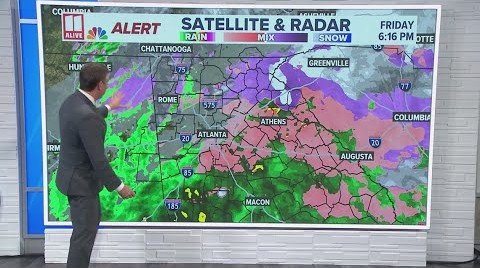
What the Radar Shows
So, what’s next? Radar indicates the main wave of freezing rain is moving out, but there’s more moisture feeding in from Alabama. That means scattered freezing rain will continue for the next few hours. By late tonight, the heavier precipitation should taper off, but the icy conditions? They’re not going anywhere just yet.
Temperatures are hovering at or below freezing across much of the state. Here in metro Atlanta, we’re sitting right at 32°F. North of the city, areas like Canton and Gainesville are just below freezing, and places like Clayton are down in the 20s. With those cold temperatures sticking around, any untreated roads will remain slick and dangerous into the morning.
Wind and Ice Combine for a Double Threat
If you’re hearing the crackle of ice outside your home, that’s the sound of branches under stress. Combine that with those gusty winds, and the risk for falling limbs and additional power outages remains high—not just tonight but into tomorrow as well.
Meteorologists are warning that the next several hours will be critical. And even as the precipitation stops overnight, strong winds will continue tomorrow, adding to the potential for more issues.
What You Should Do Now
With conditions like these, here’s what we recommend:
- Stay Off the Roads: Ice can be nearly invisible and incredibly dangerous. If you don’t absolutely need to travel, stay home.
- Prepare for Outages: If your power is still on, take this time to charge your devices and gather essentials like water, food, and flashlights.
- Report Hazards: If you see downed power lines or trees, avoid them and contact your utility provider immediately.
What to Expect Moving Forward
Looking ahead, tomorrow morning will bring icy conditions as temperatures drop even further overnight. Any moisture left on roads will refreeze, creating slick spots. By the afternoon, sunshine will make a welcome return, but it won’t be enough to fully melt all the ice. And guess what? We’re expecting another round of refreezing tomorrow night, so this cycle isn’t over just yet.
The good news? By Monday, we’re looking at a slight warm-up, with highs climbing into the 40s. But until then, it’s all about staying safe and prepared as we navigate this winter storm.
In Summary
To recap, the combination of freezing rain, ice, and strong winds is creating a dangerous situation across much of Georgia tonight. Power outages are widespread, roads are treacherous, and conditions will remain hazardous into tomorrow morning.
We’ll continue to monitor this situation and bring you updates as they come in. For now, stay inside, stay warm, and stay safe we’re with you through the storm.